Who We Are

We sold our home in June, 2007, and spent the next 7 1/2 years traveling full time in a Cross Roads Fifth Wheel. (We had been traveling during our summers for several years before going full time.) We loved the full-time lifestyle! Each summer we spent a month or two volunteering in State Parks, first in Indiana at McCormick's Creek State Park, near our family, then in later years as the grandchildren got older, at the Bluewater Lake State Park in New Mexico. We spent 6 months each winter at Cactus Gardens RV Resort in Yuma, AZ, where I worked mornings in the park office. The remaining months were spent on the road, seeing this great country of ours. Our favorite places are our National Parks. Anita loved photography and the freedom of digital photography, taking sometimes hundreds of photos in a day. We hiked as much as our legs will allow. We also really enjoyed square and round dancing as we travel across country, and meeting all the wonderful people who dance and/or travel.

But as in all things, there comes a time for change, and we decided it was time to create roots once more. In the fall of 2014, we purchased a home in Cactus Gardens, and in the spring of 2015, sold the 5th wheel. Anita also retired in the spring. We will continue to travel each summer, but for a shorter period of time. We hope to continue blogging about those trips, but it will obviously be on a more limited basis than in the past.

Please explore our past posts if you are interested in traveling this great country. You'll find an index in the left column. We hope you enjoy our blog, and appreciate all comments
Showing posts with label SD. Show all posts

Saturday, July 17, 2010

Spearfish Canyon and Deadwood

2004-07-24 -1- SD - Sturgis to Deadwood (3)Spearfish CanyonWe decided while in Belle Fourche to take a drive along Spearfish Canyon.  We began on the east side, driving through the town of Deadwood.   Once known for its notoriety of gold, gambling and gunpowder, it is now visited primarily for its 86 casinos offering possibly less riches than the gold mines of yesteryear.

However, it is still a colorful town, and maintains its western personality, at least outside in the streets.

 2004-07-24 -2- SD, Deadwood 2004-07-24 -2- SD, Deadwood (2)

 2004-07-24 -2- SD, Deadwood (3)

2004-07-24 -2- SD, Deadwood (4)Colorful mannequins adorn the upstairs windows.

2004-07-24 -2- SD, Deadwood (5)

Perhaps the two best known names in Mt. Moriah Cemetery are Wild Bill Hickok, killed in a poker game in Deadwood

2004-07-24 -3- SD, Deadwood Cemetery - Wild Bill Hickok and Calamity Jane's Gravesitesand Calamity Jane, buried next to him. 2004-07-24 -3- SD, Deadwood Cemetery - Wild Bill Hickok and Calamity Jane's Gravesites (2)The Cemetery is truly a “boot hill” high above the town.2004-07-24 -3- SD, Deadwood Cemetery - Wild Bill Hickok and Calamity Jane's Gravesites (4)

After leaving Deadwood and nearby Lead, we started the drive up the canyon, stopping for a walk to see Spearfish Falls.P1050081

P1050058

P1050079

Also along the route is the misty Bridal Veil Falls.

P1050133

P1050135

It’s a beautiful drive, winding between the canyon walls

P1050018    P1050112and along the Spearfish Creek.P1050053 

Geographical Center of the U.S.

Ever wonder where the exact geographical center of the U.S. is?  When looking at the nation as a whole, Alaska and Hawaii included, in 1959, the U.S. Coast and Geodetic Survey announced the center was 20 miles north of Belle Fourche, South Dakota, in a cow pasture.  A red stake was driven into the ground at the determined point.

In 2007, it was agreed that it would be better to erect a monument in nearby Belle Fourche, where it would be more convenient to visitors, especially taking into consideration that the survey itself is acknowledged to be within a 10-20 mile area of the designated point.

Curious as to how they found the center?  I thought the description of a “center of gravity” method was interesting.  A little long to repeat here, if you are interested read the article about half way down this page online from the Belle Fourche Chamber of Commerce:  “Center of the Nation

The large granite monument is attractively displayed at the end of a walk past the state flags of the Union.P1050151center  

P1050152

And in case you wondered…. the name Belle Fourche comes from when the area was French owned. The French explorers, admiring the confluence of the Belle Fourche and Redwater Rivers with Hay Creek, named it “Beautiful Fork”.

rapid

Monday, July 12, 2010

Mount Rushmore National Memorial

P1040349b  Did you know that in the first stages of dreaming of a mammoth rock monument in South Dakota, thoughts were of carving such western notables as Chief Red Cloud, Buffalo Bill Cody, Lewis and Clark, and various legendary Sioux warriors?  Such was the dream of Doane Robinson in the early 1920’s when he conceived the idea of a carving so big it would put South Dakota on the map.

Encouraged by the popular senator from the area, Peter Norbeck, Robinson wrote to one of American’s most prolific artists, Gutzon Borglum.  Borglum came to discuss the plan, but surprised Robinson and Norbeck by stating  that the biggest work of his life would not be dedicated to local heros; no, it had to be of national subjects who had contributed much to American history.

Four great presidential personages were chosen to represent “an eternal reminder of the birth, growth, preservation and development of a nation dedicated to democracy and the pursuit of individual liberty”.

On August 13, 1925, Borglum finally found the perfect spot for his work atop Harney Peak at 7,242 feet, the highest point between the Rockies and the Swiss Alps.  “Here is the place” he proclaimed.  “American history shall march along that skyline.”

Borglum was 60 years old in 1927 when President Calvin Coolidge dedicated the site, referring to it as a “national shrine”.  Borglum climbed to the summit and symbolically drilled 6 holes into the rock face, beginning a work that would consume the 14 remaining years of his life.

As you gaze upon  the giant heads, you can’t help but be amazed at the skill and labor involved in such a task.  Carving such remarkable likenesses on such a scale at such a height boggles the imagination.

Each head averages 60 feet tall.
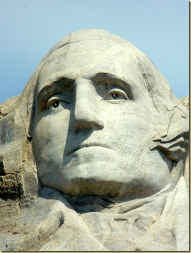
P1040404George Washington, the Father of our Country

Washington’s nose is 21 feet high.

P1040407

Thomas Jefferson,  drafter of the Declaration of Independence

Jefferson’s eyes are about 11 feet wide  and his mouth is about 18 feed wide.  He gazes slightly into the heavens, symbolizing his reputation as a visionary and philosopher.

P1040409

Theodore Roosevelt, creator of many of our National Parks. 

The detail on Roosevelt’s rimless glasses is just enough to convey a hint of them.  Roosevelt had only been dead 8 years.  Borglum designed his head from memory, having been good friends and confidants with him.

P1040410

Abraham Lincoln

Even the glint in Lincoln’s eyes have not been forgotten.

Several scenic drives surround the location.  We stayed in a campground at nearby Hermosa, south of Rapid City.   We approached the monument along the Iron Mountain Road with views through the tunnels of Mount Rushmore.P1040367 The memorial contains a large visitor center with displays and films.  The Avenue of the Flags contains four-sided columns, a state with its date of admission to the Union engraved on each side, and its flag flying atop.P1040397 At the end is a large viewing terrace.  P1040403We continued our day in the park by having lunch in nearby Hill City, and returning via the winding Needles Highway with its fantastic views and rock formations.

To view a slideshow from the day, click on the monument below.P1040411


Wall to Hermosa 

Sunday, July 11, 2010

Badlands National Park

2010-07-11 - SD - Badlands National Park 1011 Driving into the Badlands is like entering an alien world.  Your senses are assaulted by the hills made of rock rather than soil, by the fantastic colored bands,  and by the expansive views.   The area has fascinated explorers for decades, filling them with a combination of dread and fascination.  The Lakota called it mako sica; the early French trappers  described it as les mauvaises terres a traverser.  Both translate to Bad Lands.

It was hot when we visited the area in 2004 (105 degrees).  Today was hot also, but not quite as bad (92 degrees).  But it seems natural here for heat to be radiating from the stone. 

Fancy yourself on the hottest day in summer in the hottest spot of such a place without water – without an animal and scarce an insect astir – without a single flower to speak pleasant things to you and you will have some idea of the utter loneliness of the Bad Lands.” Paleontologist T. Culbertson

And yet, there is a beauty all around you.

2010-07-11 - SD - Badlands National Park 1076

The many bands of color are from the layers of deposit over the eons of minute grains of sand, silt and clay that have been cemented into solid form.

Conservationist F. Tilden described it as “peaks and valleys of delicately banded colors – colors that shift in the sunshine,…and a thousand tints that color charts do not show.  In the early morning and evening, when shadows are cast upon the infinite peaks or on a bright moonlit night when the whole region seems a part of another world, the Badlands will be an experience not easily forgotten.”

2010-07-11 - SD - Badlands National Park 1087 

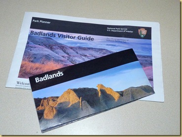
Come, take a drive through the park with us.  Click on the brochure to begin:

2010-07-11 - SD - Badlands National Park 1001

For more information on the Badlands, click here.

Saturday, July 10, 2010

Lewis and Clark Information Center near Chamberlain

2010-07-10 - SD - On the Road, Mitchell to Wall - Lewis and Clark 1001Mitchell to Wall, South Dakota

Occasionally, you just happen onto an unexpected treat while traveling, and such is the rest stop on I-90 near Chamberlain, SD.  The state has transformed the rest stop into a Lewis and Clark Information Center.  According to the displays there, the building sits very near the spot the expedition crossed the Missouri River.

The rest stops along I-90 have all had huge concrete tee pee sculptures on the grounds.  The one here overlooks the river with informative displays beneath.2010-07-10 - SD - On the Road, Mitchell to Wall - Lewis and Clark 1002 As you enter the building, your eye is drawn upward to the keelboat extending from the wall.  2010-07-10 - SD - On the Road, Mitchell to Wall - Lewis and Clark 1003The imaginative designer planned it so the stairs ascend through the bottom of the boat to the viewing deck above.2010-07-10 - SD - On the Road, Mitchell to Wall - Lewis and Clark 1004Even the crates upstairs have lids that lift up to displays.

The deck overlooks the crossing of the river towards Chamberlain.2010-07-10 - SD - On the Road, Mitchell to Wall - Lewis and Clark 10072010-07-10 - SD - On the Road, Mitchell to Wall - Lewis and Clark 1008Several other displays were in the center.

Crossing the river, we drove through rolling hills2010-07-10 - SD - On the Road, Mitchell to Wall - Lewis and Clark 1016

seeing cattle and hay fields.  2010-07-10 - SD - On the Road, Mitchell to Wall - Lewis and Clark 10172010-07-10 - SD - On the Road, Mitchell to Wall - Lewis and Clark 1023Iowa and South Dakota are high wind areas, and are using many of the modern windmills to provide energy.  The size of the windmill blades always amaze us when we pass a truck transporting one.2010-07-10 - SD - On the Road, Mitchell to Wall - Lewis and Clark 1018 Mitchell seems to be a place that attracts cheesy tourist attractions (more about that in the next blog) but you never know what you might spot next, such as this sight, (almost missed it)2010-07-10 - SD - On the Road, Mitchell to Wall - Lewis and Clark 1024or these 2010-07-10 - SD - On the Road, Mitchell to Wall - Lewis and Clark 10282010-07-10 - SD - On the Road, Mitchell to Wall - Lewis and Clark 1027

Mitchell to Wall