As we continued on through Texas, we enjoyed the many roadside flowers in bloom.


We were about 2 weeks late for the famous Texas Bluebonnets, but did spot a few in bloom at a roadside stop.

Having been on the road from Yuma to Texas, my Crazy Quilt block for the month was titled “Twilight in the Desert” and featured the highway running through the desert. For more on that project, see my craft blog at “Spare Moment Stitching”.

We spent a month in Kerrville at Take It Easy RV with good friend, Donna.


Over the years, we’ve made several friends at Take It Easy. Each Saturday several go together to the nearby restaurant Del Norte’s for breakfast.

These couples plus one more went with us to Cici’s to celebrate our 33rd anniversary.
One of the highlights of our month was a three day visit from granddaughter, Cassandra. During her visit, we took a road trip, stopping for several photo sessions on the way.

Nearby Ingram has an unusual attraction, a replica of Stonehenge and another of a statue from Easter Island.

In 1989 Doug Hill tipped on end a massive limestone rock onto Al Shepperd’s field. After looking at the rock and joking about it for months, Al and Doug decided to build an arch behind the rock to make it more visible to passers by.

With the arch, Al was reminded of the original Stonehenge in England, and commissioned Doug to design and build a stonehenge.

It took 9 months to fashion out of rebar and concrete. Stonehenge II is not an exact replica, and is not oriented to the sun. It is about 2/3 the size of the original.
After Stonehenge II was complete, it seemed a logical step to add the Easter Island statuary. Al had visited the original and thought the statue would be a natural complement to the stone structures.

You never know what you’ll find on a drive in Texas. Cassandra loved this fence topped with boots that seemed to go on forever. (She took this photo.)

The road used to have many low water crossings. After a fatal accident a few years ago, those low water bridges have been replaced with higher structures, but there are still many places for parking and photographing.


Many years ago on a drive through this area with friends, we spotted an old stone chimney, obviously all that was left of an old home. Ron thought he remembered its location, and after a lot of visual searching through the brush, we located it. The first time, we were able to walk back to the chimney, but now the brush is too thick to attempt reaching it.

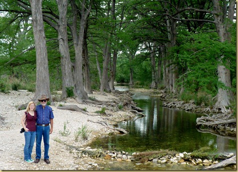
We retraced our route to Kerrville, and headed for Bandera, Texas’ Cowboy Capital. Again, there were several stops to enjoy the beautiful stream scenes.
The roadside wildflowers were prolific.


The next day, we visited Kerrville’s Riverside Nature Center, a little known attraction. It is a quiet, natural habitat for birds and butterflies. Many of the plants were in bloom.


Afterwards, we walked along the riverbank.


When we arrived in Kerrville in April, the water in the river was so low the dam near the park had just a trickle of water flowing over it. But it rained several times while we were there, increasing the water in the river dramatically. This was the scene one evening at sunset.

A few days later after another hard rain, the water flowed almost over the entire length of the dam, something Donna said she hadn’t seen for years.

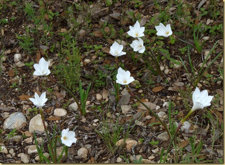
That day, I noticed the incline by the dam was covered with white flowers that hadn’t been there the day before. Mr. Kline, a 90+ year old resident of the park, told me they were “rain flowers”; following up on his tip, I discovered he was right. They are Texas Rain Lilies, and often pop up following a rain.
Following our month in Kerrville, we stopped for an overnight stay at Cedar Breaks, a C.O.E. Park near Georgetown, TX, for another visit with Cassie.
We were there for a week last fall. The change in the water levels was amazing. Here are two of the docks,
then…………………………………………………………… and now


Where there was no water in the inlet at all last fall, the docks are now floating.
The next morning, we hit the road toward Indiana.


![IMG_1900 [50%]](https://blogger.googleusercontent.com/img/b/R29vZ2xl/AVvXsEjuvCJd2mmEwtVJav55AFkBzkqCBLVUG8z9h6A3_-MI0V96g-Gt1FdHjSyP7c9SGYx7M8fHbok7e78mlPoAHHPhEUUfbj917poIdeJVzBeQN33waGaxX06enLuEhblILVK3rePsfeIwaM0/s1600-h/IMG_1900%20%5B50%25%5D%5B8%5D.jpg "IMG_1900 [50%]")
![IMG_1939 [50%]](https://blogger.googleusercontent.com/img/b/R29vZ2xl/AVvXsEjzgCOos5yB_gkWsH0ErnAaEWetcwrL354eoi1rcZQZBtY19mSxtYIpp8dtFWrE7OIbUhhrVaMjHJK7-k3JyTYktvYqfH1fcj9WfTAtiPrX4sszT59UTxw_Ozr4aKfY8JD4u202_c6oKsw/s1600-h/IMG_1939%20%5B50%25%5D%5B7%5D.jpg "IMG_1939 [50%]")
![IMG_1946 [50%]](https://blogger.googleusercontent.com/img/b/R29vZ2xl/AVvXsEhO-gFeFm7wea1HNAvssz2_Zk969kcN55LAqT0rAmqSXD86qXVk_247cKlyq8fEIr3q7bmx0PBelaS-DkfrMPq7ryGqsInFgreOA6ktLTqSCIsii_FFvhuX4ih9ZRuRNAJaG176RvWEXH4/s1600-h/IMG_1946%20%5B50%25%5D%5B6%5D.jpg "IMG_1946 [50%]")
![IMG_1989b [50%]](https://blogger.googleusercontent.com/img/b/R29vZ2xl/AVvXsEiTMX3xSAup8QJuT2VzekBl4vaNXHLde7WGyj990ZnMGoCH7aHmOR3wLghd2gPFkm781jW6l6EQ2T_LRpOcN1C805BnKudbGznezvBzab-c-7bEE1mfEVIJaNT-TiVY2A_S5LTya9uKtyU/s1600-h/IMG_1989b%20%5B50%25%5D%5B5%5D.jpg "IMG_1989b [50%]")
![IMG_2049 [50%]](https://blogger.googleusercontent.com/img/b/R29vZ2xl/AVvXsEiBZixFTDSfrIjSG84Z474ZS-sn3OZUhejT4smzxyg11B0dLuwbf445-lUcnuvMb3keaDo443Y89YJjGtxEP6HEtmyKHADrswXQFTNnvgVXtF2pSIGZUmpOKkHsl8BfwUOYo5jsWdffRu8/s1600-h/IMG_2049%20%5B50%25%5D%5B4%5D.jpg "IMG_2049 [50%]")
![IMG_2097 [50%]](https://blogger.googleusercontent.com/img/b/R29vZ2xl/AVvXsEi82cialvEA1cvaT1ilnXIhfrKaO1oHZfiN85R7STGhJRpKb9qKyEYMdZ6X-C7HHx62D8PcDsnknyLuKM4Anh6pGsqaYUmYQkaryBV3BDQlwXurIb4GuVmDYUT-HiWHr5pTyF55_QzYLCs/s1600-h/IMG_2097%20%5B50%25%5D%5B5%5D.jpg "IMG_2097 [50%]")
![IMG_2123 [50%]](https://blogger.googleusercontent.com/img/b/R29vZ2xl/AVvXsEgLprAHtBeMtIdnY_pIhtRnDWMms1WfAd5bOdidVQQLpyvQ2D1n0mOR8ib5LNKiQI34V5x7PRHgNXYoU-9AuMyjD1Bt-QHUh8iFqPPJUtz_byf9uRQJ4GXixA80FWaZEI6sWNZtbbRWlo4/s1600-h/IMG_2123%20%5B50%25%5D%5B6%5D.jpg "IMG_2123 [50%]")
![IMG_2166 [50%]](https://blogger.googleusercontent.com/img/b/R29vZ2xl/AVvXsEgjRnPXpQEobCElhdxvc-WvHLaAqo8uZ_FWvmbVKIkKo9uYtfVD38oFryPdRs7jiajzC3IFR1ITPcXTqFv8PXj2KSgvPQGikRGXEMntVwuusAe1pztgaRqyI_lqpAO-jX67pgKXQVdiF40/s1600-h/IMG_2166%20%5B50%25%5D%5B4%5D.jpg "IMG_2166 [50%]")
![IMG_2239 [50%]](https://blogger.googleusercontent.com/img/b/R29vZ2xl/AVvXsEhh07HyJT38LlJjq_9NvHO8ONihtZVTMTB7FZQFX1d5rvvfT8PCSfakW6zZiYJmHv19pkX11pAYaHmjIuXVCwF_LZr1zsyd3v0fqzL9XZkAVUyS41TkGMx_AG9MKDKliTaEgM5kfVEgr_I/s1600-h/IMG_2239%20%5B50%25%5D%5B5%5D.jpg "IMG_2239 [50%]")
![IMG_2234 [50%]](https://blogger.googleusercontent.com/img/b/R29vZ2xl/AVvXsEhxxLeqZyzwR25CfutmXwlzMti6RelGIJsd9-aUnII4uAhvcJ1_-COj1dytDOmsUr3JLacCSuCLo1a01C7suZ47JuPDbWT5ynq8dPrB_ji4PryRG-8MUEqebJ6ZRTBn3SftAYOW9xCjgNQ/s1600-h/IMG_2234%20%5B50%25%5D%5B4%5D.jpg "IMG_2234 [50%]")
![slideshow [50%]](https://blogger.googleusercontent.com/img/b/R29vZ2xl/AVvXsEiuHZ-O2GlOqEkuiZSzNJ24Xs3GCYV-pYvE_AqtqlFQURAsLJorEcfwRaugENZw14gzll8TAxl_4zyxOYcccpNpgFnhtpYaQWvzeEaygNir9lNJT4F3rpvPc-r8F16PKeJJoej7DGV6z7o/?imgmax=800 "slideshow [50%]")


