We have visited many spectacular places in the United States over the years, but few, if any, can compare to the awesomeness of the Grand Canyon. Last summer, after a visit to the Grand Canyon, a cousin commented that he "had always wondered what the big deal over a ditch was, but once he had actually seen it, he knew".
No matter how many pictures or videos you may have seen of the Grand Canyon, nothing can prepare you for actually experiencing it's vastness.
We chose to visit the South Rim this year, perhaps we'll get to the North Rim next year. It is 10 miles across the canyon to the North Rim, as the eagle flies, but 215 miles by road.
The south rim has an elevation of 7000 feet, and the weather was perfect today.
We hiked along the Rim Trail, which runs several miles next to the canyon's edge.
Many visitors to the area either hike or take a mule trip to the bottom of the canyon. It takes two days to hike down and back, and they can choose to stay at the Phantom Ranch. This facility was built in 1922 from uncut river stones from the canyon bottom and materials packed in by mule. It sits one mile straight down from the rim, but requires a hike or ride between 7 and 10 miles, depending on which trail is taken.
Can you spot the trail far below?
After a picnic lunch, we took the 25 mile drive to the East Entrance. The historic building known as the Watchtower sits at the edge of the rim. Built in the early 1900s, the structure was designed to look like a Pueblo Indian tower. Constructed of stones from the rim, it blends in beautifully with the surrounding landscape and looks as if it's been there forever. The tower has an observation deck, and inside steps leading to the top. The interior is decorated with native designs.
For more of our photos of the canyon, longhorn sheep and watchtower, take a look at our slideshow:
Thursday, September 25, 2008
Wednesday, September 24, 2008
Holbrook to Grand Canyon
We enjoyed the drive to Flagstaff, where we turned northward toward the Grand Canyon.
Many of the Flagstaff businesses date back to the Route 66 heyday.
We took the scenic route north, through the Kaibab National Forest.
The countryside is beautiful, but I wouldn't want to live here. Residents in this area are truly "off the grid" providing their own electrical power, and trucking in their water.
Our days travel seems to have really taken us back in time, as we stay overnight in "Bedrock", located in the small community of Valle, about 30 miles south of the Grand Canyon.
Tuesday, September 23, 2008
Petrified Forest National Park
or "The Painted Desert and its Trees of Stone"
Next stop on our list was the Petrified Forest National Park. We passed the entrance on I-40 as we drove toward Holbrook. Looking around, we asked each other if it was really worth the night's stay at Holbrook and the 30 mile drive back to the park. We decided we were too close to the park not to see it. After all, any national park has to be worth seeing, right? Absolutely. We are so glad we took the time to spend a day there.
The park is actually 2 parks in one, the Painted Desert and the Petrified Forest. Not visible from the interstate, we were amazed at the beauty of the desert.
The Painted Desert actually runs all the way from here to the Grand Canyon. It has been said that there are "168 distinct colors and shades in the sands of the Painted Desert, and to any beholder this seems conservative, rather that an exaggeration".
The northern half of the 28 mile park road runs through the Painted Desert. An interesting stop is the Painted Desert Inn, a museum renovated by the Civilian Conservation Corps in the 30's on the site of a popular inn on historic Route 66.
As you travel south on the road, you begin to spot chunks of petrified logs. I had a vague concept of how petrified wood was formed before visiting the park, but the movie shown at the Painted Desert Visitor Center was excellent in its explanation, as is the park brochure:
"This high, dry grassland was once a vast floodplain crossed by many streams. Tall, stately conifer trees grew along the banks. A variety of plants and animals lived there, known only as fossils today. The trees fell, and swollen streams washed them into adjacent floodplains. A mix of silt, mud and volcanic ash buried the logs. This sediment cut off oxygen and slowed the logs decay. Silica laden groundwater seeped through the logs and replaced the original wood tissues with silica deposits (cell by individual cell). Eventually the silica crystallized into quartz, and the logs were preserved as petrified wood."
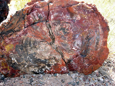
Think of that. The original wood cells were replaced, retaining the grain and texture, by gemstone! The resulting display is amazing.
The color patterns are gorgeous, including yellow, red, black, blue, brown, white and pink. Petrified wood is surprisingly heavy, weighing 200 pounds per cubic foot.
In the mid 1800's stories of this unusual place were carried back east, and before long, pioneers and sightseers were common in the area. Naturally, everyone who visited stooped to choose a piece to carry home, and much of it was pilfered to be sold locally as souvenirs. Finally in 1906, sections of the area were set aside to be federally protected, and in 1962, those areas plus more than 50,000 more acres became the Petrified Forest National Park. Today, federal law prohibits the removal of even a small chip, but only a fraction of the original petrified logs remain.
During the last few days, we have seen many reminders of the Historic Route 66, which ran through the center of the park. The community of Holbrook holds many such remnants of the "Mother Road" which made travel through the west so popular.
For more scenes from our trip through the National Park click here for our slideshow:
Monday, September 22, 2008
Cortez, CO to Holbrook, AZ
It seems that all roads in this area are good picks for scenic views. We decided to go south through New Mexico on US 419 (formerly US 666), because we had been told at the Santa Fe Visitor Center that it was newly paved. Well, the attendant was half right. It will be very nice when finished, but for now has construction continuing along much of the stretch southward to Gallup, where we turned west. Nevertheless, the scenery was striking.
Mesa Verde National Park
From the entrance of the park to the Visitor Center is over 15 miles, but it takes quite a while to drive it, because you keep stopping to admire the magnificent views and to snap pictures (lots of pictures).
The largest and most often photographed site in the park is the Cliff Palace, which can be experienced up close by taking one of the ranger-guided tours. This is looking down upon the Cliff Palace from the overlook at the start of the tour. Tours are conducted every half hour. The 60 spaces on each tour usually fill quickly.
The ancient dwellers in this area moved here around 700 a.d, and remained until 1200-1300 a.d., when they migrated to other areas of Arizona and New Mexico. No one knows why they left Mesa Verde, although a severe drought during that time probably contributed to their hunting a new homeland. Many of the present day pueblo residents are descendant from these ancient tribes.
Our tour was one of the first of the morning. It began by descending a narrow trail along the edge of the cliff.
From the trail, we could look across at another ruin.
This is a zoomed view of that ruin.
Round, below ground rooms, in the dwellings are known as kivas.
Kiva is a Hopi word meaning ceremonial room. It is believed the ancient dwellers used their kivas both as a place of worship, and as a "family room" of sorts, a cozy place to keep warm in the winter, or cool in the summer. A single family dwelling usually contains 1 kiva.
There are many kivas in the Cliff Palace, leading experts to speculate that perhaps it was not a dwelling, but a meeting place for the families in the area. The palace consists of many rooms.
The trail from the ruin to the top is very narrow between the rock walls, and terminates with a wooden ladder, similar to those the natives would have used between structure levels.
We also hiked to the Spruce Tree House, the best preserved ruin in the park. It contained 129 rooms, and probably was home to 60-90 people. A ranger is stationed there to answer questions. At this site, we were allowed to descend into a kiva. For photos from our day at Mesa Verde, click below. As you look at scenes of the cliffs, see how many cliff dwellings you can spot. There are 600 of them in the park, and a total of 4500 archaeological sites - simply amazing. It seems you can pick them out in every crevice between the rocks. Only the sheltering rock ledges have allowed them to be preserved so well throughout the centuries.
Saturday, September 20, 2008
Anasazi Heritage Center
We arrived in Cortez, CO before noon, and decided to drive 10 miles north to the Anasazi Heritage Center near Delores. The Center consists of a museum and a short trail to surface ruins. The museum was very well laid out, with several hands-on activites, as well as hundreds of artifacts. It was an afternoon well spent, and gave us insight into the lifestyle of the early pueblo residents that occupied this area.
Santa Fe, NM to Cortez, CO
On the back of a motor home recently, we saw the slogan "The trip is the destination". I won't go so far as to agree that's always the case, but there is a lot to be said about roadside scenery. We were amazed at the sights as we traveled north from Santa Fe through Chama, NM and then on to Cortez, CO. We'd like to share a few of those sights with you:
Thursday, September 18, 2008
Kasha-Katuwe Tent Rocks National Monument
While staying at Cochiti Lake, NM, we decided to hike in the nearby Kasha-Katuwe Tent Rocks National Monument. The Bureau of Land Management (BLM) manages the site, all the land surrounding it is tribal owned by the Pueblo de Cochiti. The monument is reached by a 5 mile gravel road through the desert.
The name "Kasha-Satuwe" means "white cliffs" in the traditional Keresan language of the pueblo. The landscape is remarkable, shaped by ancient volcanic eruptions.
Close inspection of the arroyos reveals small, black glassy obsidian fragments,"apache tears", embedded in the rocks. These were created by a rapid cooling of the molten flow.
There are many precariously perched boulder caps on the "hoodoos" or tent shaped structures. A 1.5 mile trek takes you up through the narrow canyon, and is captivating. For some of our photos from that hike, click on the photo below:
Wednesday, September 17, 2008
Cochiti Lake, NM
We found a nice C.O.E. park at Cochiti Lake (pronounced coach-a-tee), west of Santa Fe, and decided to stay for a week, just to to relax for a few days.
The campground was very scenic, surrounded by mountains.
We spent one day in the historical district of Santa Fe. Although it was interesting, we were somewhat disappointed in its commercialism. We had heard so much about Old Town Santa Fe, and had assumed it would retain much of the old west flavor. Many buildings have been preserved, but a large number now house upscale shops and galleries. We did enjoy the architecture though, had a nice meal, and toured the state capitol. For some of those pictures click here.
Friday, September 12, 2008
U.S. Air Force Academy at Colorado Springs
As we traveled south on I-25, we saw the sign for the U.S. Air Force Academy, and decided to stop. We are so glad we did. The grounds are impressive, and include a large Visitor's Center. We learned that we were just in time for a guided tour of the Chapel, the most visited building on the campus.
The chaplain gave a very interesting tour. The chapel, built in the 50's is a beautiful work of art, both inside and out. So many features of the building and it's furnishings contain symbols relating to the Air Force, even down to the shape of the pew backs (that of a plane's wing).
The government funded the construction of the building, but the inside has been furnished solely by contributions and gifts.
I was impressed to find religious worship playing such a large part in a military establishment. You don't expect that in an age of separation and state. In doing a little research later, I found this quote:
In the 1950s, while the United States engaged in the Cold War, American civil religion stood in contrast with “godless Communism.” Historian Sydney Ahlstrom remarked of the decade, “There seemed to be a consensus that personal religious faith was an essential element in proper patriotic commitment.” President Dwight Eisenhower summarized the non-sectarian attitude, stating, “Our government makes no sense unless it is founded on a deeply felt religious faith--and I don’t care what it is.” The Academy carefully embraced three major beliefs with distinct worship spaces in the chapel for Catholics, Protestants, and Jews, expanding in recent years to include Muslim, Buddhist and other faiths.
The chaplain did tell us that cadets are no longer required to attend the services as they were when the chapel was first built.
For a slideshow of more photos, including some from the interior of the chapel, click anywhere on this sentence.
Rocky Mountain National Park
As we entered Colorado, the way became more scenic the farther we went. We enjoyed the roadside displays of wildflowers in bloom.
We camped in Loveland, CO, about 30 miles from the Rocky Mountain National Park entrance.
As we drove to the park the next morning, we were glad we had chosen Loveland to stay in, versus Estes Park, the nearest community to the park. The drive from Loveland up wound through the Big Thompson River Canyon, and was breathtaking.
We spent two days in the Rockie's. Our only complaint would have to be the cool weather. The first night got down to 40 degrees, and there was quite a bit of cold wind in the mountains.
The first day we drove "Trail Ridge Road" the highest paved continuous road in the U.S.
We actually saw snowflakes swirling in the air on the higher elevations. (A ranger told us two weeks before we were there, a 2 foot snowfall closed the road for a few days. The poles you see on each side of the highway are there for road crews as indicators of the road edge when they are obscured by snow.)
The second day, we returned to the park to hike. The weather warmed up as the day went on. We only hiked a little over 2 miles, but due to the altitude, found the hike more strenous than we had anticipated.
For more pictures of our visit to the park, view our slideshow:
Subscribe to:
Posts (Atom)